
↓
 

Orlando Land Surveying

Local Land Surveyors in Orlando, FL

Orlando Land Surveying
  • Home
  • ALTA Survey
  • Boundary Surveying
  • Construction Survey
  • Drone LiDAR Mapping
  • Elevation Certificate
  • Land Surveying
  • Topographic Survey
  • About Us
  • Blog
  • Contact Us
Home - Page 3 << 1 2 3 4 5 … 11 12 >>

Post navigation

← Older posts
Newer posts →

Do You Need a New Home Survey When Buying an Older House?

Orlando Land Surveying Posted on June 25, 2026 by OrlandoLSJune 23, 2026
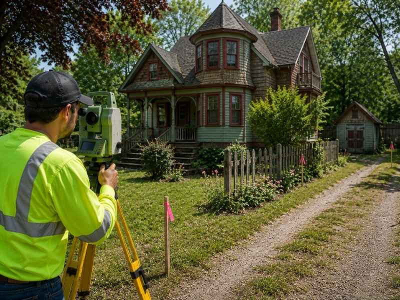
Home survey being performed on an older house to verify property lines, fences, driveway, and detached shed before closing

Buying an older house comes with questions that a newer home might not raise. Who put up that back fence? Is the shed on this property or the neighbor’s? Does the driveway cross the property line? A new home survey can help answer those questions before the sale closes. It looks at the property as it stands today. An old survey might be years or even decades out of date.

Why a Home Survey Can Be Helpful When Buying an Older House

Older homes often have a long history. Past owners may have added a deck, moved a fence, put up a storage building, or paved a side yard. None of those changes may have been recorded on any survey. The legal property description stays the same, but the physical property keeps changing.

A new home survey captures what is actually there now. A surveyor visits the property, takes measurements, and records the current state of the land and everything on it. That gives a buyer a current picture instead of one that might be ten, twenty, or thirty years old.

Lenders and title companies sometimes accept an older survey when a property changes hands. But accepting an old survey means accepting whatever it missed. A new survey shows the property as it exists today, which is what the buyer is actually purchasing.

How a Home Survey Helps Buyers Know the Property Lines

Property lines tell a buyer exactly what land they are getting with the home. Those lines may not be where a fence, a hedge row, or a garden bed suggests they are. A survey finds the true boundary and marks it.

For an older house, this matters even more. Fences get moved. Additions get built. Landscaping creeps past where it was supposed to stay. Over time, the visible edges of a property can drift away from the legal lines without anyone noticing.

A home survey uses deed records and physical evidence on the ground to locate each boundary line. The surveyor finds or sets markers at the corners and records their exact positions. A buyer can look at the survey drawing and see clearly where their land begins and ends. That removes the guesswork from one of the most basic questions in any home purchase.

What a Home Survey Can Tell You About Fences, Sheds, and Driveways

A home survey shows more than just the property lines. It also maps the features that are already on the land. That includes fences, sheds, garages, driveways, patios, and any other structures or improvements the current and past owners added over the years.

Each of those features gets measured and placed on the survey drawing in relation to the property lines and boundaries. A buyer can see whether the back fence sits on the property line, inside it, or past it onto a neighbor’s land. They can see whether the detached garage sits within setback requirements or sits too close to the line.

These details matter because they can affect what a buyer is able to do with the property after they purchase it. A shed sitting in an easement might need to be moved. A driveway that crosses the property line might require an agreement with a neighbor. Knowing about these things before closing gives a buyer time to ask questions and get answers while they still have options.

Why an Old Home Survey May Not Show Recent Changes

A survey captures a property at one point in time. Whatever was on the land the day the surveyor visited is what the survey shows. Anything added, removed, or changed after that visit does not appear.

For an older home, the gap between the last survey and today might span many years. In that time, a previous owner might have put up a fence that crosses a boundary line. They might have built an addition that sits closer to the property line than local rules allow. A driveway might have been widened. A deck might have been added without a permit.

None of those changes show up on the old survey. A buyer relying on that old document gets a picture of how the property looked under a past owner. That is not the same as how it looks today. A new survey fills that gap and shows the current state of the land and every structure on it.

How a Home Survey Gives Buyers More Confidence Before Closing

Buying a home is one of the largest purchases most people make. Going into that purchase with clear, current information about the property helps buyers feel prepared rather than uncertain.

A new home survey gives buyers specific answers to specific questions. Where are the property lines? Are the structures within those lines? Does anything on the property cross into an easement or onto a neighbor’s land? Are there any features that might be a problem after the sale?

Having those answers before closing means a buyer is not left to find out after the papers are signed. If the survey turns up something unexpected, there is still time to ask the seller about it. A buyer can negotiate or decide whether to move forward. That ability to make a decision with full information is worth a lot in a transaction as significant as buying a home.

Frequently Asked Questions

Why should I get a home survey when buying an older house?

 Older properties often have changes that were never recorded on any survey. A new survey shows the current state of the land and all the structures on it. That gives you accurate, up-to-date information about exactly what you are buying before the sale closes.

How does a home survey show where the property lines are?

 A surveyor uses deed records and physical evidence on the ground to locate each boundary. They find or set markers at the corners and record their positions on a drawing. That drawing shows clearly where the property begins and ends.

Can a home survey show fences, sheds, and other features?

 Yes. A home survey maps structures and improvements already on the property. It shows where each one sits in relation to the boundary lines. That includes fences, sheds, garages, driveways, and patios.

Why might an old home survey no longer be accurate?

 A survey only shows what was on the property the day the surveyor visited. Fences, additions, driveways, and other changes made after that visit do not appear on the old document. The older the survey, the more likely it is to be missing something that matters today.

How can a home survey help me feel more confident about buying an older house?

 It gives you current, specific answers about the property lines, structures, and any features that might be a concern. Going into closing with that information means fewer surprises after the sale is done.
Posted in land surveyor | Tagged land surveyor

How a Construction Surveyor Helps Prevent Costly Building Mistakes

Orlando Land Surveying Posted on June 24, 2026 by OrlandoLSJune 23, 2026
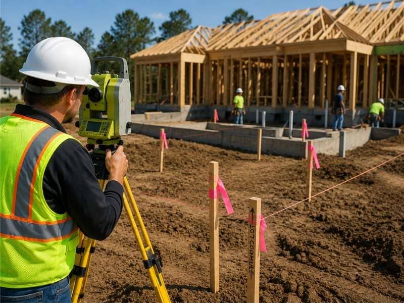
Construction surveyor using a total station to verify layout points and prevent costly building mistakes during residential construction

Building in the wrong spot, at the wrong angle, or at the wrong height can cost a lot to fix. Sometimes the whole structure has to come down and get rebuilt. A construction surveyor helps prevent that from happening. They mark key points on the ground and check measurements during the build. They also make sure structures end up where they are supposed to be.

Why a Construction Surveyor Helps Builders Start in the Right Spot

Before any digging or building begins, a construction surveyor goes to the site and marks the locations that builders will use as their starting points. These marks show where the corners of a building go and where the foundation edge sits. They also show where other key features will be placed.

Getting the starting point right is one of the most important parts of any construction project. A building that starts in the wrong spot will finish in the wrong spot. Moving a structure after the foundation is poured costs far more than setting the right marks before work begins.

Surveyors use the legal property description and any approved site plans to figure out exactly where each mark should go. They measure from confirmed points on the land and place stakes or pins. The construction crew uses those marks to guide their work. Those marks become the reference points for every step that follows.

How a Construction Surveyor Uses Measurements to Prevent Mistakes

Measurements on a construction site need to be exact. A difference of a few inches can push a wall outside a setback line or move a driveway into an easement. It can also shift a building close enough to the property line to cause problems during permitting or a future sale.

A construction surveyor uses tools designed to measure with high accuracy. Levels, total stations, and GPS equipment help the surveyor take readings far more precise than what a tape measure can produce. That precision is what makes the difference. Those tools help catch small errors before they turn into big ones.

Mistakes that get caught early are cheap to fix. A stake moved two feet before the foundation is poured takes a few minutes to correct. That same two-foot error found after framing is done can mean tearing out work and starting those sections over. New concrete, new lumber, more time.

How a Construction Surveyor Helps Keep Structures in the Right Place

Every structure on a lot has to sit within certain limits. Local rules set how far a building must sit from the property line. Easements restrict where driveways and utility connections can go. Approved site plans show where each feature should be placed.

A construction surveyor checks that each structure ends up in the right place as the project moves forward. They measure the position of walls, foundations, driveways, and other features and compare those measurements to what the plans require.

This checking process matters most at the stages where changes are still easy to make. A wall that is two feet off during framing can be corrected before the roof goes on. The same problem found after the building is fully enclosed is much harder and more expensive to fix.

Surveyors also make sure that features like driveways and sidewalks do not cross into easements or onto neighboring property. Those problems can show up during permit inspections or when the property is sold. Catching them during construction saves a lot of time and trouble.

Why a Construction Surveyor Can Help Reduce Costly Rework

Rework is one of the biggest sources of extra cost on a construction project. It happens when something gets built wrong and has to be removed, corrected, and rebuilt. A misplaced wall, a foundation poured at the wrong elevation, or a garage that overlaps a setback line can all require rework.

The cost of rework goes beyond the materials and labor to redo the work itself. It also includes delays to the rest of the project. Other trades waiting to come in cannot start until the rework is done. A schedule that slips by two weeks because of one mistake can affect the whole project timeline.

A construction surveyor reduces the chance of rework by checking the work at key points during the build. When measurements are verified before the next stage begins, errors get caught while they are still small and easy to fix. A foundation that gets checked before framing starts will not turn into a framing problem. A wall position confirmed before drywall goes up will not become a drywall problem.

How a Construction Surveyor Supports a Project From Start to Finish

A construction surveyor does not just show up once and leave. On most projects, they come back at different stages to take new measurements and check that the work is staying on track.

At the start of a project, they set the layout marks that guide the crew. During foundation work, they check that the slab or footings are at the right height and in the right position. As framing goes up, they can verify that walls are where the plans show them. Near the end of a project, they may take the final measurements needed to prepare the as-built record.

Each check gives the project team current, accurate information. Problems spotted during one stage do not carry forward into the next. That steady flow of accurate measurements helps the job move forward with fewer stops and fewer surprises. Less money gets spent fixing things that should not have needed fixing.

A construction project involves a lot of people working from a lot of different plans. A construction surveyor gives them all a shared, accurate set of measurements to work from. That common starting point is what helps keep a complex project from going in too many different directions at once.

Frequently Asked Questions

What does a construction surveyor do before construction begins?

 A construction surveyor marks the key locations on the ground that builders use as starting points. Those marks show where a foundation corner goes, where a building edge sits, and where other features will be placed. Getting these marks right before work starts reduces the chance of costly mistakes.

How does a construction surveyor help prevent costly building errors?

 They take precise measurements using leveling equipment, total stations, and GPS tools. Those measurements guide where structures get placed and help catch errors before they carry forward into the next stage of the build. Mistakes found early cost far less to fix than ones found late.

Why are measurements so important during a construction project?

 Small errors in measurement can push a building outside a setback line, move a driveway into an easement, or place a structure too close to a property line. Each of those problems can cause delays, permit issues, or require expensive rework. Accurate measurements help avoid all of them.

Can a construction surveyor help avoid rework?

 Yes. By checking measurements at key stages during the build, a construction surveyor helps catch errors while they are still small. A problem found before the next stage begins is much cheaper to fix. Finding it after more work is stacked on top of it costs a lot more.

Why might a construction surveyor stay involved throughout the project?

 Different stages of construction need different checks. Layout marks are set at the start. Foundation height gets verified early. Wall positions get checked during framing. Each stage builds on the one before it. Accurate measurements at every step help stop errors from stacking up across the whole project.

Posted in construction | Tagged construction survey

What an As-Built Survey Reveals After Construction Is Complete

Orlando Land Surveying Posted on June 23, 2026 by OrlandoLSJune 23, 2026
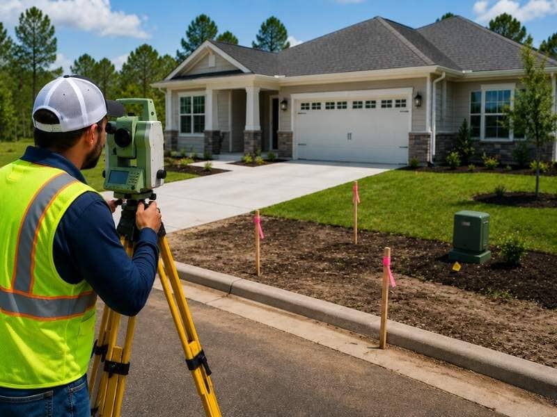
As-built survey being performed after construction is complete to document the final layout of a residential property

When construction ends, the finished project does not always look exactly like the original plans. Walls shift a few inches. Driveways end up slightly wider. Utility lines get rerouted. An as-built survey captures all of that. It measures what was actually built and records it in a document that shows the final layout of the property. That record becomes useful for future work, permit closures, and property sales.

How As-Built Surveys Show the Final Layout of a Property

An as-built survey is done after construction is finished. A surveyor goes to the site and measures what was built. That includes buildings, driveways, sidewalks, fences, and utility connections, along with anything else added or changed during the project.

Those measurements get recorded in a drawing that shows where everything ended up. The drawing reflects the real finished state of the property, not what the plans said it would look like. That is the key difference between an as-built survey and a construction drawing. One shows the plan. The other shows what actually happened.

Property owners, builders, and local offices all use as-built surveys for different reasons. A homeowner might need one to close out a building permit. A builder might need one to hand off a finished project to a client. A future contractor planning an addition will want to know where the existing plumbing and electrical lines actually run. That is hard to know without a survey.

Why As-Built Surveys Can Find Changes Made During Construction

Construction projects change as they go. A wall gets moved a foot to the left because of a pipe that was not on the original plans. A driveway gets widened because the homeowner changed their mind during the build. A utility trench takes a different path because the original route hit rock underground.

These changes happen on almost every project. They are often small and made quickly to keep the job moving. But they do not always get written down in a way that is easy to find later. The original plans stay on file, but the changes made in the field may not be captured anywhere.

An as-built survey fixes that. The surveyor measures what is there after everything is done. If the finished driveway is two feet wider than the plans showed, the survey records it. If a building sits three inches closer to the property line than the permit allowed, the survey shows that too. Finding those differences early gives the property owner time to address them before they become problems later.

What As-Built Surveys Reveal About the Location of Structures

Knowing where a structure sits on a property matters more than it might seem. A building that ended up too close to a property line could violate setback rules. A fence built during construction might cross into an easement. A patio added at the end of a project might sit closer to a neighbor’s lot than local rules allow.

An as-built survey measures each structure’s distance from the property lines, from other structures, and from any easements on the property. Those measurements show whether everything is where it is supposed to be.

This also matters when a property changes hands. A buyer wants to know that the structures they are purchasing sit within the legal limits of the lot. A title company may require survey documentation before insuring the property. An as-built survey provides that documentation. It shows the exact position of each completed feature on a drawing tied back to the legal property boundary.

Why As-Built Surveys Matter More as Development Continues to Grow

As more homes and buildings get built, the need for accurate records grows with them. Properties sit closer together. Lot lines matter more when neighbors are only a few feet apart. Easements for utilities and drainage cut across more parcels. Small mistakes in placement become harder to fix the more built-up an area gets.

An as-built survey creates a clear, dated record of what was built and where. That record helps resolve questions that come up years after a project is done. If a neighbor disputes a fence location, the as-built survey shows where it was placed at the time of construction. That takes the guesswork out. A future owner planning an addition can check the as-built survey. It shows how much space sits between the building and the lot line.

Property records that include as-built surveys are also more useful to local offices. A permit office or utility company can check the as-built survey to find out what is on a lot. It gives them reliable information to work from.

How Land Surveyors Use As-Built Surveys to Create Lasting Records

A land surveyor performing an as-built survey starts by reviewing the original construction plans and any permits that were pulled for the project. That review gives the surveyor a starting point and a list of features to look for on the ground.

The surveyor then visits the finished site and takes measurements of each completed feature. Buildings get measured from multiple points to confirm their size and position. Driveways and sidewalks get measured for width and location. Utility connections, drainage structures, and any other site improvements get recorded as well.

All of those measurements tie back to the property’s legal boundary. That connection is what makes the survey useful over time. The drawing shows where things are in relation to lot lines, easements, and other legal features of the property. That connection is what makes the survey useful over time.

The finished as-built drawing becomes a permanent record. It can be filed with the local permit office, kept by the property owner, or shared with a title company. Future contractors can use it too. Every time someone needs to know what is on that lot, the as-built survey gives them an accurate starting point.

Frequently Asked Questions

What information do as-built surveys provide after construction is complete?

 An as-built survey records the final location of buildings, driveways, sidewalks, utility connections, and other features that were added or changed during construction. It shows what was actually built on the property, not just what the original plans called for.

Why are as-built surveys important when a project is finished?

 They confirm that completed features sit within the correct distances from property lines, easements, and other structures. They also create a dated record that helps future owners, contractors, and permit offices understand what is on the lot.

Can as-built surveys show changes that happened during construction?

 Yes. The survey measures what is on the ground after work is done. That means any changes made during the build will show up in the drawing. A wall moved during framing, a wider driveway, or a rerouted utility line will all show up in the as-built drawing.

Why are as-built surveys becoming more important as development grows?

 As more properties get developed and lots sit closer together, accurate records of what was built and where become more valuable. An as-built survey creates a clear record that helps resolve future questions about structure placement, property lines, and easements.

How do land surveyors perform as-built surveys?

 The surveyor reviews the original plans, then visits the finished site and measures each completed feature. Those measurements tie back to the legal property boundary. They get recorded in a drawing that shows the final layout of the property.

Posted in construction

Post navigation

← Older posts
Newer posts →
Get Quote Button

The owner of this website, USA Surveying & Engineering, LLC., provides coordination of professional land surveying and engineering services in all 50 states. The professional surveying and engineering services provided to you will be conducted by fully licensed professionals in your state.

Privacy Policy
↑