Before any building project starts, someone needs to learn about the land. Not just what it looks like from the road, but the actual shape of the ground, what’s sitting on it, and how water moves across it. That’s where LiDAR mapping helps. When used with a topographic survey, it gives builders, engineers, and planners some of the most accurate land information available today.
LiDAR Mapping Gives a Clear View of the Land
LiDAR stands for Light Detection and Ranging. It works by sending out fast bursts of laser light and measuring how long each burst takes to come back. From those return times, it figures out the exact distance to whatever the light touched, whether that’s open ground, tree branches, a rooftop, or a slope.
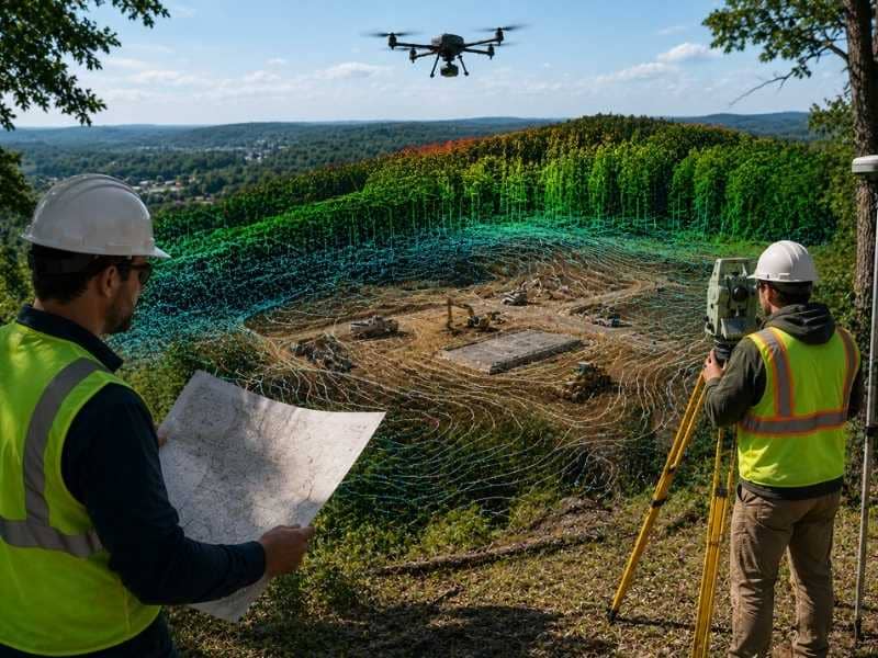
The biggest advantage of LiDAR mapping is how much it collects at once. One pass over a property can record millions of data points. Those points come together to form a 3D picture of the land that shows every hill, dip, and height change across the site.
Ground crews can’t always walk every part of a large or heavily wooded property. LiDAR solves that by working from above, usually attached to a drone or small plane. It can even see through thick trees and read the ground below them, which regular photos and satellite images can’t do.
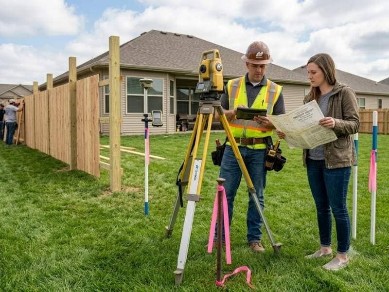
Topographic Surveys Show What Is on the Site
A topographic survey works differently. While LiDAR focuses on the shape and height of the ground, a topographic survey records what’s actually on the land.
Surveyors write down the location of buildings, roads, trees, fences, power lines, drainage ditches, and other things on the property. They measure the slopes and grades across the site and note anything that could affect how the land gets used. The final product is a detailed map showing both natural features and man-made ones, exactly as they look today.
This type of survey is used on most building projects. Engineers use it to plan drainage, figure out grading, and decide where buildings will go. Without it, too much gets left to guesswork.
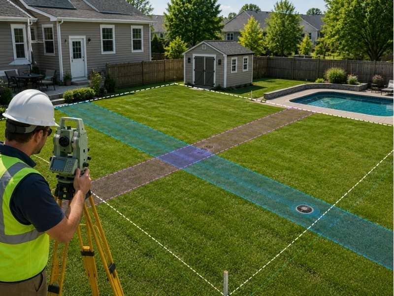
Using Both Gives Better Results
LiDAR mapping and topographic surveys answer different questions. That’s exactly why they work well as a team.
LiDAR gathers terrain details fast, even on large or hard-to-reach land. A topographic survey records the specific things on that land and connects all the measurements to fixed, reliable points. Together, they cover what the other one misses.
Picture a builder planning a new neighborhood on a wooded piece of land. LiDAR can scan the whole property fast and show the terrain hiding under the trees. The topographic survey then records the roads, drainage areas, power lines, and structures already on the site. The engineer gets the full picture, terrain data from LiDAR plus feature details from the ground survey, and can plan with confidence from day one.
Without both, gaps show up. LiDAR alone won’t catch every utility line or man-made structure. A topographic survey alone on a large, tree-covered site can miss small height changes that affect where water flows. Together, they fill those gaps.
Growth Means Better Maps Matter
New homes, roads, stores, and other buildings are going up quickly in many areas. When land gets developed this fast, having good information about that land matters more than ever.
Tight timelines leave little room for plan changes caused by surprise terrain problems or drainage issues that weren’t mapped correctly. A project that starts with good land data moves faster and runs into fewer problems. One that starts with bad or missing data often gets stuck when things in the field don’t match what’s on paper.
LiDAR mapping fits into busy project schedules well because it gathers a lot of data in a short time. Paired with a fresh topographic survey, it gives project teams the land details they need to make good choices at every step.
Good Land Data Helps Every Project
The value of good survey data shows up long before any digging starts.
Engineers use terrain models from LiDAR mapping to plan grading work and drainage systems. Architects use topographic data to place buildings in spots that work with the existing slopes. Environmental workers use elevation data to find areas that flood easily or contain wetlands. Utility crews use it to plan where lines will go with fewer problems and lower costs.
When the data is good, everyone on the team works from the same clear picture of the land. That cuts down on confusion, reduces changes during construction, and helps projects finish on time and on budget. When the data is wrong or old, those issues show up as expensive problems once work has already started.
Good land data isn’t a bonus on big projects. It’s what every smart decision depends on.
Frequently Asked Questions
What is LiDAR mapping used for?
LiDAR mapping measures the shape and height of the ground across a property. It’s used in construction, engineering, environmental work, and land development to build accurate terrain models before any design work begins.
What does a topographic survey include?
A topographic survey records the physical features on a piece of land. That includes buildings, roads, trees, fences, utility lines, drainage areas, and slope information. It gives designers and engineers a clear picture of what’s already on the site.
Why use LiDAR mapping and a topographic survey together?
LiDAR gathers terrain data quickly across large or hard-to-reach areas. A topographic survey records specific features and ties all measurements to reliable reference points. Together, they give a fuller and more accurate picture of a site than either one can on its own.
Can LiDAR mapping work on large properties?
Yes. LiDAR works especially well on large properties because it collects data from above and covers big areas quickly. One flight can cover hundreds of acres and record millions of data points, which is much faster than measuring everything by foot.
Who needs LiDAR mapping services?
Builders, engineers, land developers, environmental workers, and utility planners all use LiDAR mapping. Any project that needs accurate terrain data before building starts can benefit, especially on sites that are large, heavily wooded, or hard to reach on foot.
How long does a LiDAR mapping project take?
It depends on the size of the property and the complexity of the project. Data collection for a small to mid-size site can often be done in one day. Turning that data into a finished terrain model usually takes a few more days, with bigger or more complex projects taking longer.