
How Drone LiDAR Mapping Makes Property Surveys More Accurate
Traditional ground surveys get the job done. But on large or complex sites, they take time, cost more in labor, and can miss elevation details that only show up when you’re standing in the wrong spot. Drone LiDAR mapping changes that. It collects thousands of data points per second from above, producing a level of site detail that ground crews alone can’t match at the same speed. For developers, that accuracy matters long before construction starts.
What LiDAR Actually Does
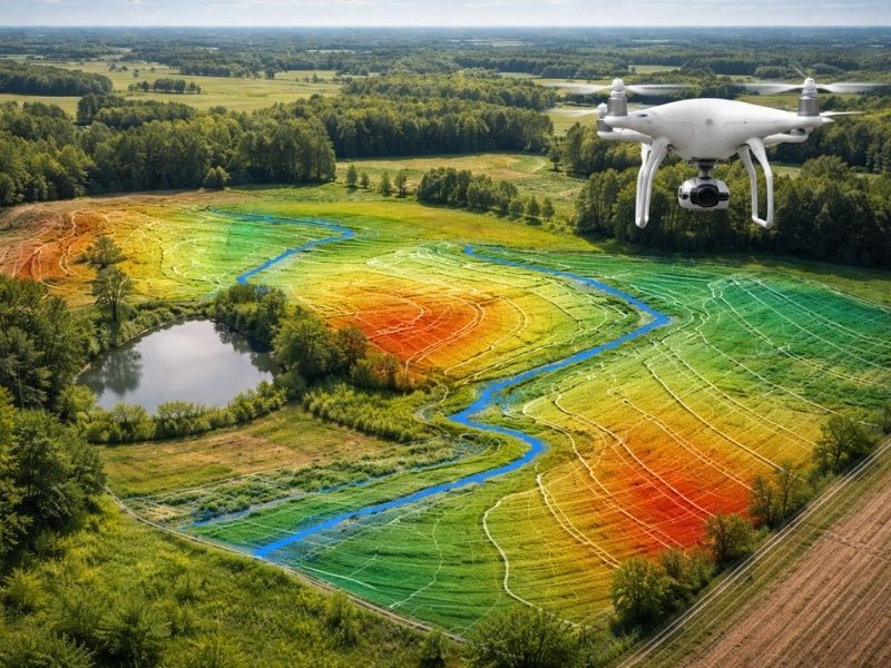
LiDAR stands for Light Detection and Ranging. A sensor fires rapid laser pulses at the ground and measures how long each pulse takes to bounce back. Do that millions of times across a property and you get a dense, three-dimensional point cloud of the entire site.
That point cloud shows:
- Exact ground elevations across the full site
- Slope angles and grade transitions
- Tree canopy height and ground level beneath it
- Structures, retaining walls, and paved surfaces
- Low spots, berms, and drainage channels
A standard ground survey captures elevation at specific measured points. LiDAR captures everything in between. That gap matters when the site has uneven terrain, dense vegetation, or drainage features that affect where and how you can build.
How Drone LiDAR Mapping Works on a Property Survey
A licensed surveyor operates the drone within FAA regulations. The drone flies a pre-planned grid pattern over the site while the LiDAR sensor collects data continuously. Ground control points, set by the survey crew before the flight, tie the aerial data to real-world coordinates.
After the flight, the raw point cloud gets processed into usable survey products:
- Digital elevation models (DEMs)
- Contour maps at tight intervals
- Surface models showing existing conditions
- Accurate base maps for civil engineering and site design
The whole data collection process on a mid-sized parcel can take a few hours instead of several days. Processing adds time, but the finished product is typically delivered faster than a traditional ground-only survey on comparable sites.
Why Accuracy Improves With LiDAR
Dense Data Coverage
A ground crew collects elevation shots at selected locations. A LiDAR sensor collects hundreds of points per square meter across the entire site without stopping. That density catches slope changes, drainage swales, and grade breaks that spot measurements miss.
On a site with rolling terrain or heavy vegetation, those missed details can mean the difference between a drainage plan that works and one that causes problems after construction.
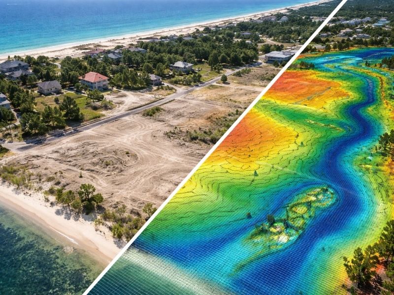
Ground Returns Through Vegetation
One common objection to aerial surveys is tree cover. LiDAR handles this better than photogrammetry (photo-based drone surveys). The laser pulses can pass through gaps in tree canopy and return ground-level readings beneath the trees. The software filters out vegetation returns and keeps the ground data.
That matters on wooded development sites where photogrammetry would show the top of the tree canopy instead of the actual ground.
Fewer Return Trips to the Site
When ground crews survey large sites manually, conditions sometimes require going back. Missed shots, changed conditions, or scope additions all trigger return visits. LiDAR data collection is thorough enough that most sites don’t need a second flight for the same scope of work.
For developers managing tight project timelines, fewer site visits from the survey team means fewer delays at the front end of design.
Where Drone LiDAR Mapping Fits in a Development Project
LiDAR is most useful during the early stages of a project. The data feeds directly into:
- Topographic surveys for civil engineering
- Grading and cut/fill calculations
- Stormwater and drainage design
- Site feasibility studies on raw land
- Environmental assessments on parcels with wetlands or natural features
It’s also used during construction for progress tracking and as-built documentation on large grading projects. A drone flight over a graded site gives the engineer a current surface model without sending a crew to walk every inch of the pad.
Drone LiDAR vs. Traditional Ground Survey
Neither method replaces the other. They serve different roles.
Ground surveys are precise for boundary work, property corners, and legal documentation. A licensed surveyor still needs to set control points, verify monuments, and certify boundary information. LiDAR doesn’t replace that work.
What LiDAR improves is the topographic data collection layer. On sites under an acre, a ground crew may be faster. On sites over five acres, especially those with varied terrain or tree cover, drone LiDAR typically produces more complete data in less time.
The combination of both methods gives developers the most complete picture of a site before design begins.
Frequently Asked Questions
What is drone LiDAR mapping in property surveying?
It’s a method where a drone-mounted LiDAR sensor collects millions of elevation measurements across a property during a single flight. The result is a dense, accurate three-dimensional map of the site used for engineering, grading, and site design.
How accurate is drone LiDAR for land surveys?
When tied to properly set ground control points, drone LiDAR surveys typically achieve vertical accuracy within 5 to 10 centimeters. Some high-precision systems reach accuracy closer to 2 to 3 centimeters. Accuracy depends on sensor quality, flight altitude, and ground control setup.
Can drone LiDAR work on sites with heavy tree cover?
Yes. LiDAR pulses can pass through gaps in tree canopy and return ground-level readings beneath the trees. The processing software separates vegetation returns from ground returns, producing a bare-earth model even on wooded sites.
Is a drone LiDAR survey a substitute for a boundary survey?
No. LiDAR collects terrain data, not legal boundary information. A licensed surveyor still needs to locate property corners, research legal descriptions, and certify the boundary. LiDAR works alongside boundary surveying, not instead of it.
When should a developer order a drone LiDAR survey?
Before site design begins. The data feeds into topographic surveys, grading plans, drainage design, and feasibility studies. Ordering it early gives the civil engineer accurate base data to work with before any design decisions are made.