
Why Builders Order a Topographic Survey Before Breaking Ground
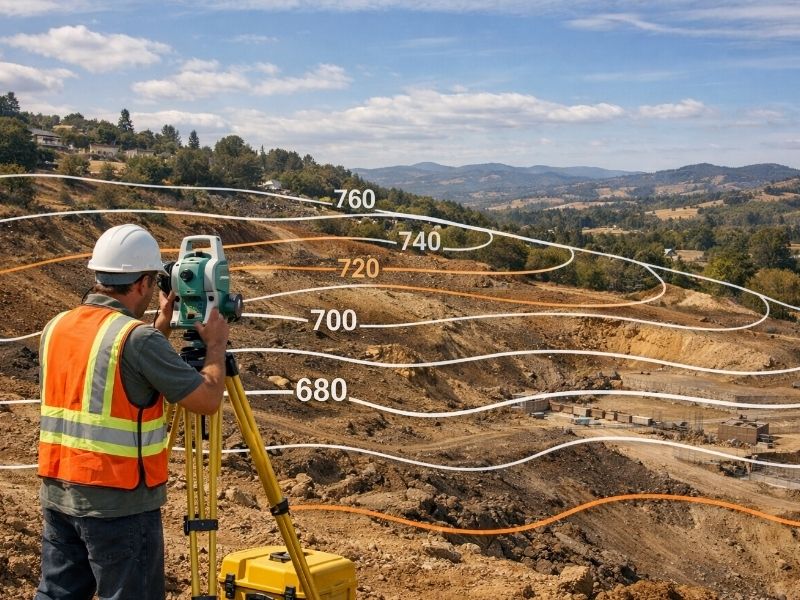
A topographic survey shows the exact shape of the land. Every slope, dip, drainage path, and elevation change gets mapped before a single shovel hits the ground. Builders who skip this step often find out the hard way that flat-looking land is never truly flat.
What a Topographic Survey Actually Shows
Most people think a plot of land is straightforward. It has edges, it has a size, and that’s mostly it.
Not quite.
A topo survey maps the physical features of a site in detail. That includes:
- Ground elevation at multiple points
- Slopes and grade changes
- Natural drainage paths and low spots
- Trees, vegetation, and ground cover
- Existing structures or improvements
- Utility lines and underground infrastructure (where visible)
- Retaining walls, curbs, and paved surfaces
That data gets turned into a contour map. Each contour line represents a specific elevation. The closer together those lines are, the steeper the slope. A site that looks level on a plat map can show serious grade changes on a topo.
Why Builders Need a Topographic Survey Before Breaking Ground
Grading and Site Prep Depend on It
Before any grading plan gets drawn, the engineer needs to know what the land actually looks like. Without topo data, grading estimates are guesses. Guesses lead to change orders. Change orders cost money.
A topo survey gives the grading contractor real numbers to work with. How much dirt needs to move? Where does it go? Where does the cut balance with fill? These questions can’t be answered from a deed or a property boundary line.
Drainage Planning Starts Here
Water follows grade. If a builder doesn’t know which direction the land drains, water ends up where nobody planned for it. That might mean a flooded foundation, standing water in a parking lot, or runoff pushing into a neighboring property.
A topo survey maps the natural drainage patterns across the site. Engineers use that data to design stormwater systems that actually work. Getting drainage wrong at the design stage is far cheaper to fix than getting it wrong after construction.
It Feeds Directly Into Engineering and Permitting
Most civil engineers won’t draw a site plan without topo data. Building departments in most jurisdictions require a grading plan with elevation information as part of the permit application.
A topographic survey is the starting point for that work. Skipping it doesn’t save time. It creates a bottleneck because the engineer has to stop and wait for the data anyway.
What Happens When Builders Skip It
Some builders try to work from aerial imagery or county GIS data. Those tools have their place, but they’re not a substitute for a licensed survey.
GIS elevation data is often collected at a low resolution. It doesn’t show small-scale grade changes that matter for foundation design and drainage. Aerial imagery shows surface features but not precise elevation.
The result? Design drawings that don’t match the actual site. When the crew shows up to grade, they find conditions that nobody accounted for. That triggers redesigns, delays, and cost overruns.
One significant grading mistake on a mid-sized project can cost more than the entire survey fee several times over.
When to Order a Topographic Survey
The right time is before design begins. Not during. Not after.
Ordering a topo survey early gives the architect and civil engineer real site data to work with from the start. It prevents the back-and-forth of designing something, then discovering the site won’t support it.
For most construction projects, the sequence looks like this:
- Site acquisition
- Topographic survey
- Boundary survey (if not already completed)
- Geotechnical investigation
- Civil engineering and site design
- Permit application
Topo data informs nearly every step after step two. Starting design before it’s done adds risk to every decision made after that point.
How a Topographic Survey Works
A licensed surveyor sends a field crew to the site. They collect elevation readings across the property using GPS equipment, total stations, or drone-mounted sensors depending on the size and complexity of the site.
Drone LiDAR has become common for larger sites. It captures dense elevation data quickly and produces highly accurate contour maps. For smaller sites, ground crews do the same work on foot.
The finished product is a survey drawing with contour lines, spot elevations, and existing feature locations. That file goes to the civil engineer, who uses it as the base layer for the site plan.
Turnaround time varies by site size, but most residential and light commercial topo surveys are completed within one to two weeks.
Frequently Asked Questions
What is a topographic survey used for in construction?
It maps the elevation, slope, and physical features of a site. Engineers use it to design grading plans, drainage systems, and foundation layouts. Builders need it before site design begins.
How is a topographic survey different from a boundary survey?
A boundary survey marks property lines. A topographic survey maps the physical shape of the land within those lines. Both are typically needed for new construction, but they serve different purposes.
Do I need a topographic survey for a small project?
Size isn’t the only factor. Even a small site with drainage concerns, significant grade changes, or a tight permit requirement may need topo data. Check with your civil engineer before assuming it’s not needed.
How accurate is a topographic survey?
A survey completed by a licensed professional using modern equipment is accurate to within a few centimeters vertically. That level of accuracy matters for foundation design and drainage calculations.
How long does a topographic survey take?
Field work on a typical residential or small commercial site takes one to two days. The finished drawing is usually delivered within one to two weeks after fieldwork is complete.